 4
4Practically all automakers and individual development companies are focused on interstates and city roads. The only major group that seems to be working on unmarked roads/inclement weather conditions is MIT, though there are some other groups doing individual research1,2,3
The majority of "last mile" roads in suburban and rural areas do not pass these criteria. For example, many are unmarked or even paved at all in the case of rural areas and roads that are marked with a center line will most likely not have a line marking the outside of the road.
A few reasons, a specific one is it makes the problem easier. Only working on these roads permits a few assumptions about what a road is and what its condition will be like:
These situations likely cover the vast majority of where most people are most frequently driving. Furthermore, roads like these are probably traveled for long periods of time in one sitting meaning these roads are likely where automation can provide the most benefit.
Another reason is that it's not cost effective yet. Many techniques used to develop autonomous vehicle systems rely on a lot of data to be trained on and are thrown off by situations that do not closely match the training data. There are large variations in unmarked roads and the cost to acquire and train on the data required would likely be cost prohibitive. Most groups are densely mapping the areas they intended to drive in to get enough data but many unmarked roads (especially rural ones) haven't yet been added to Google StreetView, so the probability of high density mapping scans are probably low. Furthermore, many rural car buyers are likely unable to afford the high cost these systems will have in the short term.
While suburban roads are far more similar than their rural counterparts making them easier to develop for, they will still not be considered in the short term primarily due to being "last mile" roads. For the foreseeable future, drivers of autonomous and semi-autonomous vehicles will require a vehicle operator's license (drivers license). As the operator will leave the vehicle at the destination, it can be expected that the operator will be awake and alert (or can be awoken and alerted) to operate the last segment. Similarly, when beginning a journey, the operator will be awake and alert and can be relied upon to navigate the vehicle to a suitable road. Since these are typically very short distances, it does not provide much value to the end user.
I'm surrounded by unmarked roads. Even the side streets of the cities are frequently unmarked (and don't get me started about unmarked parking lanes). Even if these were marked, it snows here. A lot. The storms last for a long time and it doesn't often get cleaned quickly or thoroughly so if you want to do anything in those few days, you're dealing with occluded roads.
I'm interested in the long term. Operating a vehicle is typically the most dangerous activity in which you will regularly partake, both for occupants of the vehicle and those outside the vehicle. As people age, they become less capable of operating a vehicle. Many of these people living in the suburbs and rural areas are unable to walk or have access to public transit to necessary destinations like grocery stores. If there is transportation service provided, these people will continue to drive, likely beyond when they are physically capable becoming a clear and present danger to all users of the roads. This trend isn't stopping. The population is increasingly aging and aging in place is becoming more popular. Transit systems in these areas are both financially and politically nonviable. A private transportation system is needed to fill this demand.
Another group that is incapable as operating a vehicle are the visually impaired. I know a number of people whose visual impairment is progressing and losing their sight means losing their independence. I'll probably be among them one day and I'd like to hedge a couple bets against the medical field figuring out how to solve them all.
Tesla vehicles have been able to navigate some unmarked roads for some time, but these systems are Level 2+ at best which require full operator attention at all times. It should be noted that the system does have behaviors like avoiding pedestrians on the side of the road5, but does not perform other typical behaviors like avoiding potholes and roadkill or keeping appropriate distance from industrial equipment6. Comma.ai's OpenPilot is also able to navigate these "laneless" roads7, but this system is a third-party add on that is also a Level 2+ system.
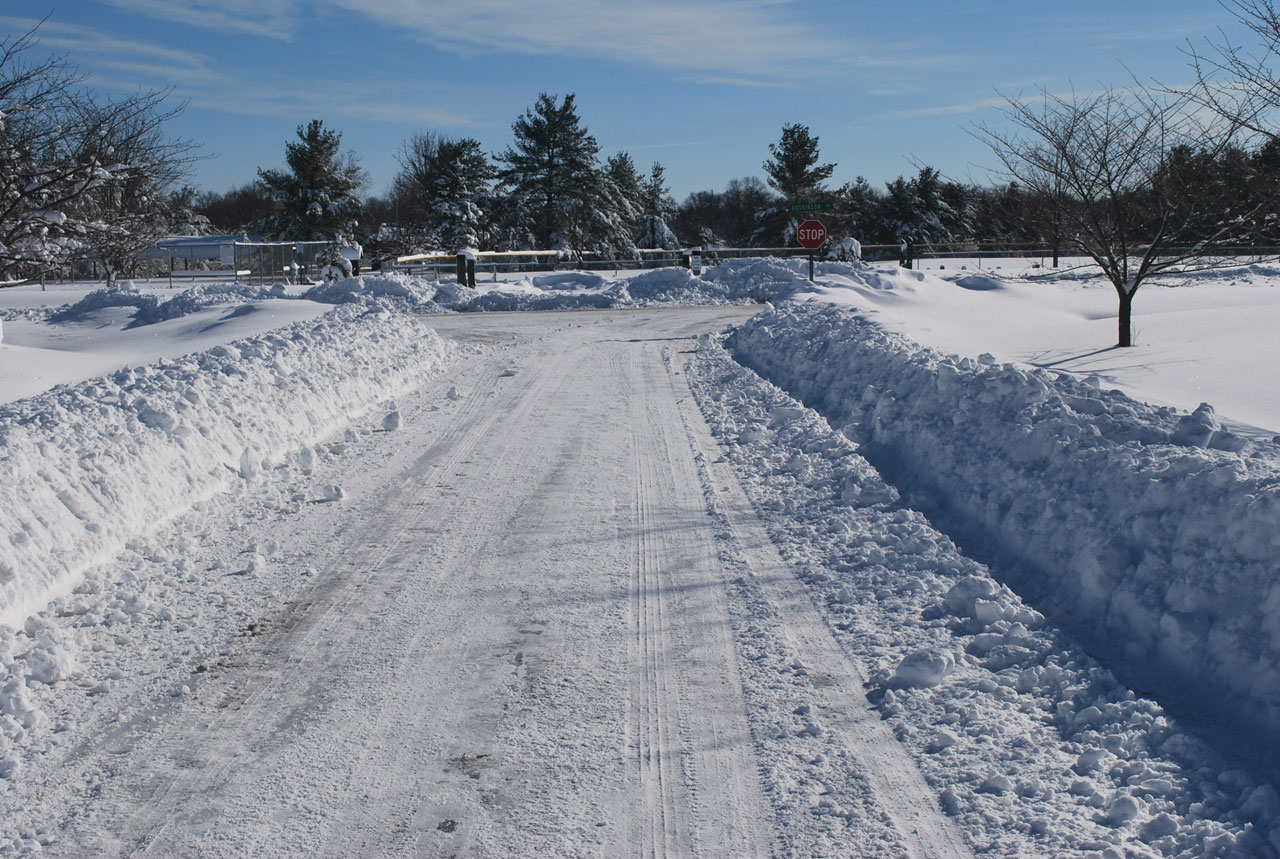
The stereo camera has trouble with the lack of texture, but LIDAR works really well. Due to the high albedo (reflectivity) of snow, LIDAR actually performs better in snow. Asphalt, however, has a low albedo so as conditions improve, the LIDAR becomes less effective. This will be able to be used to discern road surface from snow banks more effectively. Before the snow is plowed, if you find it difficult to see the edges, this system probably will too. Once the snow is plowed, the problem becomes extremely easy with LIDAR. It's like driving down a road lined with jersey barriers; borders are obvious and well defined.
An example of the jersey barrier-esque plowed snow:
The color filter matches pretty much all snow surfaces, but the LIDAR would clearly see the surfaces at the edge extremely steep angles and exclude it. The crumbled snow near the edges of the snowbank may prove to be a problem for the system. Flatness tolerances may have to be speed dependent.
This will mostly be handled by integration with GPS/maps. The system currently only maintains a locally referenced map, so it has no sense of which road is the correct one to take. GPS gives a globally referenced map, but only to a certain precision at which point the vision system can take over. If turns are blocked by something like another car, this can largely be handled by maintaining the proper distance from the vehicle in front or slowing down when the turn is approaching to allow cars on the other side of the road to move out of the way.